Thursday, August 20, 2009

Bushwick

Before I get started on last Saturday's walk . . . I mention the Brooklyn Library a lot here, mainly because I am there almost each weekend and my walks generally radiate from there. For anyone reading this who isn't from Brooklyn, I wanted to show you the Central Library at Grand Army Plaza. Merely walking into the place adds pleasure to whatever books I borrow . . .


(I don't have to mention, do I, that you can click on any image to get a full-size version?)

Saturday walk (August 15: up Bushwick Avenue from Metropolitan Avenue to the top at Eastern Parkway; down the other side onto Pennsylvania Avenue through East New York (actually it appears to be the border between East New York and Brownsville); down to Linden Blvd. (which is like a miniature version of the LIE); down Linden to Rockaway Ave. (it was supposed to be Rockaway Blvd. about a quarter mile further on but I got confused; the two join up eventually anyway and I doubt that there is much difference); down Rockaway Ave./Blvd. through Canarsie to Flatlands Avenue; along Flatlands across Brooklyn until it met Kings Highway (it ends about a half a block before that and turned into Ave. N, which then intersected with Kings Highway); Kings Highway to Ocean Parkway; down Ocean Parkway to Gravesend Neck Rd. (Gravesend Neck Rd. is a small street but from the map I would say it goes right through the center of the original settlement of Gravesend, but I have to confirm that); across this street to Van Sicklen Street (there is a similarly named avenue in East New York but spelled without the “k”). I took Van Sicklen up to Kings Highway where it ended; a dogleg onto West 1st Street up to 65th Street; down 65th to 24th Avenue, which I then took over to McDonald Avenue. I took McDonald up into Flatbush, turning down Church Avenue and then snaking through parts of Flatbush around the Parade Ground and around to Ocean Avenue to Flatbush Ave. to Vanderbilt Avenue to Lafayette Avenue to Clinton Avenue to Willoughby Avenue to Washington Avenue to Park Avenue to Bedford Avenue to Grand Street (whew!) to home. I took the mileage from the nyc.gov map and it came to 20.62 miles. Now that’s not an exact measurement since it comes from the map, but it’s good enough for rock ‘n’ roll and may even be shorting me some mileage (or so I’d like to think).


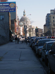
Near the Metropolitan Ave. end of Bushwick Ave.

I was surprised by Bushwick Avenue. I know it only as the gritty commercial/industrial strip down by Metropolitan Avenue or the Bushwick Avenue of Bushwick Houses. If it’s in the news at all it’s generally because of a crime, like the murder of the Ecuadorian man last December or the killing of a woman by a stray bullet as she was sitting outside her apartment one recent afternoon.


Housing on lower Bushwick Ave. (right); Bushwick Houses in the background


Bushwick Houses (New York City Housing Authority)

But after you cross Myrtle Avenue it becomes almost totally residential. It’s not exactly Fort Greene but, probably because it became a lower income neighborhood over the years, there wasn’t the kind of rebuilding you see in other places (like what is happening in Williamsburg), so most of the original buildings remain.


Bushwick Ave. just above Myrtle Ave.

There are still decent sized trees along the avenue, something I always look for and that I think adds a lot to a street’s appeal (but then I grew up in the suburbs so greenery is always going to occupy an important place in my life). The avenue is wide and the buildings are not high so there is a free, airy feeling there.


Willoughby and Bushwick Aves.; a half block above Myrtle Ave.

I don’t mean, either, that all the buildings along Bushwick Avenue are architectural gems, but most of them are interesting looking, or so I think, and they don’t all look the same like some giant sat down and stamped them all out with a cookie cutter, but I’m just not a partisan of most contemporary architecture, at least not where it would be out of place.


Bushwick Ave. near Lawton St.

Bushwick Avenue could easily be an attractive street and neighborhood again if the buildings were fixed up a bit. But not at the expense of driving out the people who live there now. Yet, that’s exactly what could and probably would happen. Already lower down Bushwick there is an influx of people attracted to the area because of what you might call “the Williamsburg Effect.” That whole end of Brooklyn has become very hip and trendy and is now becoming very “costly,” as a friend of mine used to say. (I read a story in the Times a couple of weeks ago about a gourmet grocery and wine store opening on Wyckoff Avenue in Bushwick http://www.nytimes.com/2009/07/22/nyregion/22bushwick.html?scp=1&sq=Bushwick&st=cse. That’s six blocks away from Bushwick Avenue, further east. They must expect an influx of people to give them business.)


Garden St. where it meets Bushwick Ave.


Bushwick Ave. near Noll St.

So far, the construction is on lower Bushwick but it’s probably only a matter of time before it heads up the avenue. And the new buildings on lower Bushwick are actually not bad; given their surroundings they are an improvement (see the pictures above). But further up they would be out of place. All along that upper part of Bushwick you are only a short block from Broadway and the J/Z line. And when you get close to the top you are near the Broadway Junction stop of the A/C/L/J/Z trains, a desirable situation, transitly speaking.

So, I fear a little for its future. Developers don’t particularly care about the look or feel of a neighborhood after it becomes popular, just about money and maximizing the income they can get from a particular building site, so relying on them to preserve the housing stock there in the name of Brooklyn history or even pleasant living is a bit silly. Those ubiquitous green glass behemoths that have been popping up in the rest of Brooklyn may well be headed that way. Now that I think about it, even the people that move in after a neighborhood becomes popular don’t care too much about the look of the place. That doesn’t make a lot of sense but, again, if Williamsburg is anything to go by, it’s true. I guess the attitude is, “Well, it’s there, someone might as well live in it and I can afford to, so . . .”


Washington Ave. between Myrtle and Park Aves.

Look, for instance, at this shot of Washington Avenue in Clinton Hill (above). The area west of Myrtle Avenue is just outside of the well known brownstone district of Clinton Hill and Fort Greene so there’s no reason why developers can’t do anything they like there, but to see this fifteen or so story glass box looming over a neighborhood or 2- and 3-story buildings is a little sad. Then again, people will keep moving to Brooklyn and the people in Brooklyn will keep starting families and life goes on and where are they all going to live . . . and I don’t have the answer. I try not to act like a livery stable owner complaining about Henry Ford’s new contraption but I’m not too successful. I think if some of these places just fit into their neighborhoods better, it wouldn’t be as bad.

Look at a couple of examples from my neighborhood (below). I’m waiting for the saltine boxes get a bit further along to see if they’re going to be sheathed in green glass, the high rise “envelope” of the moment over there.


North 7th St. between Bedford Ave. and Berry St.


Berry St. near north 4th St.

But there are exceptions. There was an empty lot down the street from me in Williamsburg that always looked pleasant because the owner kept it freshly graveled and the adjoining neighbors kept displays of flowers and then one day it was boarded up for construction.


Grand St. near Bedford Ave.

People were disappointed but, I think, much less disappointed when the new building started going up (above) and it turned out to fit into the neighborhood really well. And there is this other building on a block just off Bedford (the white brick building below). Some effort was made to fit it into the scale and look of the neighborhood.


North 5th St. between Bedford Ave. and Berry St.

But, speaking of architectural gems and to get back to Bushwick, I did run across two buildings that should definitely be preserved (and probably will be for the immediate future, library budgets being what they are): two of the original Carnegie libraries built in Brooklyn, the Bushwick branch and the DeKalb branch. Over the years, the Brooklyn Library replaced other Carnegie libraries with functional, red brick boxes that add little to their neighborhoods or even the pleasure of visiting a library.


Bushwick branch of the Brooklyn Public Library, in the shadow of the Bushwick Houses


DeKalb branch of the Brooklyn Public Library at Bushwick and DeKalb Aves.

And further up the avenue, there is a real classic, a Dutch Reformed Church dating to 1852, badly in need of a coat of white paint but still proudly standing.


Dutch Reformed Church at Bushwick and Lafayette Aves.

More of Bushwick later, and the rest of that day. This is all I have the energy for tonight. And, as usual, any additions, corrections, and amplifications are sincerely welcome.

Thursday, August 13, 2009

To Coney Part 1

You know, I am not only walking all over creation on the weekend, all over Brooklyn, anyway, but also walking from work in midtown home to Brooklyn every evening. So, I don’t often have the energy to jump at the computer, write up whatever it is I want to say, and post it.

I was chagrined, disappointed, the whole thing. I found a setting on my digital camera awhile ago that allows me to take about 4 seconds of audio each time I take a photo. This is a great thing for me. I can take a hundred photos on a long walk on a good afternoon (like last Saturday) and I go through so many neighborhoods, most for the first time, that I can’t possibly remember where every photo was taken.

But the settings on my camera seem to change at a whim; maybe I hit a reset button without knowing. On Saturday, on my way out for my walk, I turned on something with a microphone symbol that had been off and was sure that it was the audio accompaniment to the photos. I took close to 120 photos across southeastern Brooklyn. Each time I took a photo I spoke into the camera, I am sure there were people who saw me and thought I was nuts talking to my camera. Anyway, when I got home and downloaded the photos there wasn’t even one audio file. Damn!

Actually, now that I think of it, probably no one thought I was nuts speaking into my camera considering all the Bluetooth devices around, they probably thought I was talking to someone. Except for that little old lady who looked at me strangely in front of St. Athanasius’s Church at Bay Parkway and 61st (you see, those damn churches again!).


But speaking of those damn churches again, they do help in situations like Saturday’s, I have a few photos here that I took along Bay Parkway but could not remember where (even though I recall speaking the cross street into the camera). What I did remember was that they were taken in front of St. Athanasius Church (Hope Happiness Joy Faith Honor . . . they look like something that would be across from a church) because I remember moving out of the way when that little old lady who was crossing the street stepped on to the sidewalk. In fact, it occurred to me that she could be headed to the church for a novena or something. I download the photos . . . no audio. Where the hell did I take them? Let’s go to the map. The two photos following show street signs saying, respectively 79th and 81st Streets, so I know this photo was taken before that. I checked the map for a large corner building lot that would hold a church, across the street from another one large enough for a school and, Bob’s your uncle, St. Athanasius at 61st Street and Bay Parkway. But more of Bay Parkway later, that was at the other end of the day’s jaunt.

To get back to the start of the day. Seeing that the weather was supposed to be nice (and the next day was supposed to be rainy), I decided this was the Coney Island day. I mean, August is getting close to half done and I still have Canarsie and a few other places left to visit, and I’d really love to finish phase 1 by Labor Day. Phase 1 meaning I have walked through or into every neighborhood in Brooklyn. I don’t know what phase 2 will be, probably getting deeper into a particular neighborhood or, when winter comes, maybe using the Brooklyn collection at the library to get more background on these places.


I had checked out a likely route on my invaluable map during the week and remembered there being two ways I could go but forgot which one was better. And someone was on the PC when I was ready to leave so I thought the hell with it, I’ll just wing it. As long as I’m heading in the general direction, I’ll get there eventually. Actually, that’s the beauty of these walks, it’s almost better to get lost than to know exactly where I’m going


Library first; I had a couple of uninteresting mystery paperbacks to return (one unread, which is unlike me). After that the choice was: Flatbush to Ocean Avenue or Prospect Park West to McDonald Avenue. Having been down PPW only a week or two ago, I decided on Flatbush. I like Ocean Avenue. Of course, I wasn’t around when it was one of Brooklyn’s fashionable middle-class neighborhoods with its pseudo-Gothic and Art Deco apartment buildings but it still retains a lot of its charm.


The avenue is still lined with mature shade trees and the buildings are well kept up. I get a kick out of many of the names (see the pictures above). They sound like they came out of The Adventures of Robin Hood (MGM version). I also like the idea of naming the avenue because it takes you straight out to the ocean.


And I am still amazed at how one street can make such a big difference between a neighborhood (or two). On Bedford Avenue, as soon as you cross Flatbush Avenue, you go from seedy to suburban. On Ocean Avenue, though the change isn’t quite as dramatic it is obvious when you cross Dorchester Road. You can see it very clearly on the aerial shot here. You are crossing from Prospect Park South into Ditmas Park; from the ranks of urban apartment buildings to houses in their own ample yards, many surrounded by shrubbery, some almost obscured by 100-year-old trees.


Go another block past Dorchester to Ditmas Avenue and turn right and you might as well not even be in Brooklyn any longer; at least not the Brooklyn of Williamsburg or Bed-Stuy or Sunset Park or downtown. In fact, it almost seems like you might as well not be in the 21st century any longer (or even the 20th).


Walking through some of the streets of Ditmas Park, I had the eerie feeling that someone was going to jump down the front steps from the broad verandah of one of the houses and shout that President McKinley had just been shot! You get the idea that the word “gracious” might have been coined just to describe these houses and this neighborhood.


Some of the ones along Ocean Avenue actually remind me of a Raymond Chandler or Perry Mason mystery from 1930s Los Angeles. Maybe it’s the tiled roofs but whenever I read one of those books, these are the kinds of houses I am imagining the characters live in. They look like a remnant of a time when life may have been just a little easier (notwithstanding a depression and a world war) Brooklyn as time machine; go figure.


On the other hand, the houses in Ditmas Park itself look like something out of Booth Tarkington where the living is easy and the summers are long and leisured (imagine the cars aren't there); broad verandahs on tall Victorian houses with gables galore shaded by ranks of Norway maples (if that’s what they are, I’m not great at trees).


And then . . . there is Coney Island Avenue. That is if you keep walking far enough. You see, that’s what many of these Brooklyn neighborhoods are like, sort of like squares on a hop-scotch game. You come upon them suddenly, walk through them, and then walk into a totally different part of the borough, maybe a little more upscale, maybe a little more ordinary, maybe really down and out. But you will pass through that, too. The word is “diverse,” big time! And that really is the beauty of Brooklyn.

So, five blocks past the sun scorched commercial strip of Coney Island Avenue you are at Ocean Parkway. Besides Eastern Parkway, I think this was the only other one of Calvert Vaux’s plans for a broad sweeping highway from Prospect Park to achieve reality. I’ll check into that. I don’t know if it’s the same width as Eastern Parkway but it feels wider and more spacious. Maybe it was all in my mind: I know I am headed toward the beaches and the sweep of ocean and sky and that gives me a feeling of freedom as I walk.

I had meant to take Ocean Parkway all the way to the beach but was sidetracked by another lure: Bay Parkway, veering off to the right for parts unknown. Who could resist a side trip down an avenue with that name? Not me. More . . . later.

Sunday, August 9, 2009

"Younity" Building Art, Williamsburg


I was going to post something about my Saturday walk to Coney Island (one more nail in the coffin, so to speak, of my aim to walk all of the borough of Brooklyn this summer) and I even have quite a bit of it typed up for posting, but instead I want to drop in something here about “Younity.”


Younity is a Female Urban Arts Collective. I happened on them this afternoon coming back from a walk in Fort Greene and Clinton Hill. When I got to Bedford Avenue and South 5th Street here in Williamsburg, I noticed a large crowd hanging around a building on the corner.


On coming closer I saw that it was a group of people using the side of the building to paint a colorful and festive mural. Half of the crowd was the women painting and the other half were intrigued passersby like me taking pictures with everything from the most sophisticated SLRs all the way down to cell phones.


One of the women explained to me who they were and pointed out women from all over the world up on ladders or sitting on steps painting.


I recommend your visiting their website

http://www.theyounity.com

(sorry, but blogger refuses to insert a link tonight)

and perhaps even visiting


For me, I’m just hoping their building mural survives the usual Williamsburg spray-paint vandalism.


I started to take some videos of the women at work but had forgotten all my photos of the day before, and the fact that I hadn't recharged the camera battery. Sure enough, right after the end of this, the battery died.

Wednesday, August 5, 2009

New York City Map

I discovered, through an small story in the New York Times several years ago, a wonderful resource on the nyc.gov web site. It is an interactive map of all five boroughs of the city that was developed by the Department of Information Technology and Telecommunications (DoITT). I have provided a link to it on the home page of this blog for anyone who is interested.

I like maps, I always have. I could spend hours looking at and reading maps, which is maybe the reason that I am fascinated by this one. All I know is I couldn't have planned most of my walks through Brooklyn without it, or figured out so easily where I'd been when I got home.


With a couple of clicks of the mouse you can go from a view of all five boroughs down to a view of one block and all the building lots and buildings on that block.

You can chose a traditional two dimensional map view or a photographic aerial view.


When you are at the building/building lot level you can choose the "i" icon and click on a building and a window will pop up giving you all the information on that building including the square footage, number of floors, owner, date of construction, the zoning map it appears on, etc.


And what has become a very valuable tool for my own walks, you can calculate distance from one point to any other point along the map.

A couple of caveats: I am not sure all the building construction dates are absolutely accurate; some of them don't jibe with dates I happen to know. Also, lately it hasn't been working too well with Firefox, or at least with my Firefox application, and I have had to open it in Explorer.

That much said, it is really a wonderful map and I have suggested to the DoITT that it should not be buried so deep in the city web site but should be linked to on the nyc.gov home page.

Tuesday, August 4, 2009

The Giglio Feast

Though most of my walking has been concentrated on the the other side of Brooklyn miles away from Williamsburg, I didn't have to stray far from home for this post, a walk of only three or four blocks.


Here in Brooklyn, the feast of St. Paulinus (or San Paolino di Nola), celebrated in June by the church calendar, is celebrated in early July at the church of Our Lady of Mt. Carmel in Williamsburg in order to coincide with the feast of Our Lady of Mt. Carmel. This is the site of the well known giglio dance. A traditional highpoint of the Williamsburg summer, this year the first day of the 122nd annual feast was Sunday, July 12.


San Paolino was a 5th century bishop in the town of Nola in Italy. (Nola is near Naples in the Campania region.) According to one of the stories attached to Paolino, while he was bishop the children of Nola were being kidnapped and enslaved by the barbarian Huns. A woman of the town asked him if he could try to free her child, which he agreed to do. The only way he could free the boy was to offer himself as a slave in the boy's place. He remained a slave for some years until the Huns decided to free him. However, he refused to return to Nola without all of the people of the town who had likewise been enslaved, which the Huns agreed to. Bishop Paolino then returned to Nola by boat and was greeted by the joyous townsfolk who met the boat carrying lilies.


The feast commemorating the return of San Paolino to Nola eventually came to include what is today the dance of the giglio (giglio being the Italian word for lily). As a representation of the lily, the present day giglio is a tall open-frame, needle-like structure surmounted by a statue of Paolino and mounted on a platform large enough to hold a small band along with several other people. The giglio is also adorned with portraits of the Blessed Mother, Sacred Heart, and other religious symbols. The celebration of the feast was brought to Williamsburg over a hundred years ago by the people of Nola who settled here.

I assume most people know the words of the Star Spangled Banner (of which only the end is on the video, anyway), but if anyone wishes to follow the singing of the Italian national anthem, the verse sung at the feast in the video below is here:

Fratelli d'Italia,
l'Italia s'e' desta,
dell'elmo di Scipio
s'e cinta la testa.
Dov'e la vittoria?
Le porga la chioma,
che schiava di Roma
Iddio la creo'.


The giglio tower stands at one end of the block in front of the church. At the other end is another structure representing the boat that carried the bishop on his return to Nola. The dance symbolizes the saint’s return as both the giglio and the boat are carried toward each other, finally meeting in front of the church. A man who was standing next to me on that first Sunday referred to this as “the kiss” and called it the emotional high point of the celebration. “It’s just beautiful,” he said, shaking his head in wonder. You can see this special moment in the video below.


All the movements of the giglio, the lifting, carrying, swaying, turning, are done at the direction of the capo, perhaps the most honored position at the feast. In the videos here you will hear the capo shouting out the directions to the lifters. As one indication of how honored a man is to be chosen a capo, he will generally dedicate the different lifts to his family members, wife, children, and so on.

The video below gives a good close-up view of the men who expend a great deal of their strength, sweat, and love to carry the giglio during the feast.


Given that you have enough men to lift and carry the giglio, it might seem like a simple task to move the platform one short block to the church, but the whole ceremony takes several hours. It begins with the blessing of the giglio and the lifters and the singing of the American and Italian national anthems. The enjoyment comes from the different lifts and turns, the singing and the other ceremonials involved, like stopping to pay respects to the family of a past capo.


It is not all just the giglio dance, of course. As with any respectable church feast there are rides for the kids, fun and games, sausage & peppers, calzone, zeppole, old and new friends and neighbors, that magic mix that summer memories are made of.

The giglio feast is certainly one of the high points of the parish year and, like a homecoming celebration, is said to draw back each summer scores of people who have moved out of the parish. Add to these the parishioners themselves, the other residents of Williamsburg who come to enjoy the feast, people from all over Brooklyn, people from outside of Brooklyn, well, you get the picture.


Especially on the opening day of the feast, there are thousands of people congregating mainly in the two blocks of Havemeyer Street in front of the church. I was surprised I got any pictures at all since each time I held the camera up it seemed like someone walked in front of me or jumped up in front of me or started waving to someone in front of me or jostled me to get by.


You do have to be down in the crowd to experience the excitement when the men lift and dance with the giglio, but I have to say that to get some good pictures I would love to have been on the roof of one of the buildings overlooking the church. If anyone reading this lives in one of those buildings and wants to invite over a giglio lover next July, I wouldn’t say no!


I am not anything like an expert on the giglio feast since this was the first one I had gone to, so if anyone wants to correct my errors or add more information or share their own memories in a comment, please do, I would really welcome it.