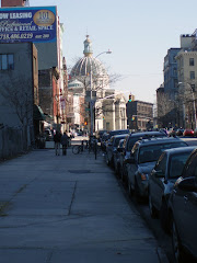
I haven't much reason to go down to the riverfront area of Williamsburg. My walking and all my errands take me off in other directions so I'm unlikely to go much nearer the river than Berry Street, which is two blocks away. But toiling through that last posting made me curious about what's been happening in those nine or ten blocks lately. Turns out . . . a lot
I walked over there this afternoon to take a short photo tour. I began at Grand Street since south of there is only the old Domino Sugar factory and not much has been happening to that lately, meaning it hasn't been torn down to make way for something more contemporary (and shouldn't be, either).

Instead of linking to a Google map this time, I thought I'd just drop in a portion of the NYC map for that area to get you oriented, though the streets just go in numerical order and I'm not going to stray from Kent Ave.much (that's the thoroughfare bordering the riverfront property).
At the foot of Grand Street is the Grand Ferry Park, a little blip on the river with some benches and a nice view of Manhattan.

That's the end of Grand Street with the park beyond; actually, it's not at all a bad place to go to catch some river breezes on a humid summer night or to read a book on a spring afternoon. You can't argue with the view. And as small as it is, it is infinitely nicer than the excuse for a park further north that's supposed to be a sop for putting up with the skyscrapers in our midst.
 Grand Ferry ParkNearby is a narrow street called River Street that only goes a few block north. There isn't anything to it, just a remnant of Williamsburg's industrial riverfront past, but I wanted to check out any other streets that might go down to the water
.
 And no, no more ways down to the East River, just fences across the street openings, which didn't surprise me.
 North 1st Street

Metropolitan Avenue
 North 3rd Street
Those views of the water, though, are so enticing; so near and yet so far. I didn't realize there were many big waves along that part of the river, still you never know when you may need a surf board . . .
 River Street near Metropolitan Ave.
I was thinking that it probably won't be long before that disappears unless the denizens of the skyscrapers want to keep a few "quaint" businesses around as a reminder of Williamsburg's seafaring past (there were a lot of ferries at one time).
But then it's back out to Kent Ave. for the real action.
 North 3rd St & Kent Ave.
At least the developers are getting colorful in their construction netting. If they kept it that way all the time we could at least pretend it was a Christo.
 To N. 4th St. & Kent Ave.
About a year ago they changed the traffic pattern on Kent Ave. from a a two-way to a one-way street, heading north, and as they did on Broadway in the city, they painted in all those cute little rectangles for cars to park in the middle of the street. And since you already feel like you're walking at the bottom of a canyon it's very crowded and claustrophobic.
 North 4th St. & Kent Ave.
There are a number of these wide driveways that lead toward the river but there is always a fence or barrier of some kind at the other end between you and the water. At least at the one large apartment building on the river south of Broadway, the public has access to a nice waterfront esplanade behind the building. Maybe, when all is said and done around here, the same situation will develop . . . maybe.
 North 4th St. & Kent Ave.
I mentioned in an earlier post about a Duane-Reade that was planned for a large new building almost completed at Bedford Avenue at North 3rd St, across from our neighborhood pharmacy, King's. True to form, Duane-Reade fills almost the entire block here, so you can see why they would want to open another on Bedford Ave. A three-block walk for a bottle of water is intolerable; I always figured it was part of their master plan to have no New Yorker more than a block away from a Duane-Reade store.
 North 5th St. & Kent Ave.
Finally a tall building. I was looking through my photo files and beginning to think I had imagined these giants.
 North 5th St. & Kent Ave.
And more!
 North 6th St. & Kent Ave.
And more!
Back at North 5th St. you can wander down what is either a street or a private driveway, I am not sure which. There are no signs saying "Private Property" "Residents Only" "Keep Out--This Means YOU"! But the street doesn't show on the map either.
 North 5th & Kent Ave.
And there are stores and sidewalks so maybe the public is welcome or maybe it's even an extension of N. 5th. Not that this always matters; on maps Washington Avenue is always shown as cutting through the old Brooklyn Navy Yard and connecting with Clymer St. but even now that it's New York City property and no longer federal, the public is still kept out.
Still, there is this sign along the roadway above . . .

North 5th Street Pier. Hmm. There is nothing there now as you can see; a fence and some construction equipment. But maybe there is actually going to be a "pier" on the river with public access at some future date.
 North 6th St. & Kent Ave.
That looks promising, too . . . so far.
What fascinates me is the contrast between the two sides of Kent Avenue. One one side Metropolis or Gotham City, on the other Smalltown, U.S.A.
 North 6th St. & Kent Ave.
 North 7th St. & Kent Ave.
 North 8th St. & Kent Ave.
Maybe the developers will want to keep those blocks intact as a sort of Olde Williamsburgh theme park.
East River State Park
"Look, Ma! A state park!! Our own state park right here in Williamsburg! Ain't we lucky?"
 North 8th St. & Kent Ave.
 East River State Park
"Look at those cobblestones, ma! This sure is historical!"
 East River State Park
 East River State Park
You would be hard pressed to find a more desolate stretch of land in the vicinity. Oh, like Grand Ferry Park, the view can't be faulted . . .
 View from East River State Park
. . . but to call it a park is a bit of a stretch. In fact, look at this view (again from the NYC map) of the area from 1996:

Those two large parallel white rectangles near the bottom left are the site of the park. You can see that the buildings were taken down to the foundations (which were left) and some benches and trash cans were scattered around. They didn't even have to plant grass.
 East River State Park
 East River State Park
Or maybe the state has a grudge for some reason because a scant block away further north is a city park . . . and behind this unassuming entrance

lurks a gorgeous soccer field with a view to die for.
 Bushwick Inlet Park
 Bushwick Inlet Park
And the damn thing is . . . we're nowhere near Bushwick.
At the end of this post is a link to an area map in case all the streets and avenues get too confusing.
Once you get south of 7th Street the new construction peters out, at least compared to what is going on in the blocks north of that point. It's spotty; a building here, a building there, some small, some large, but rarely an entire block or even most of one except for that block between North 3rd and 4th Streets and Bedford Ave. and Berry Street. And some have stopped and started and stopped again and started again so many times that it's hard to remember how long they've been going along.
 Grand St. at Driggs Ave.
For instance, one project (above) has limped along for at least a year if not longer, one loses track. After the previous building was torn down, a red brick one-story commercial affair, the lot was empty for the better part of a year before construction started up last year. It got this far and stopped again months ago.
Down the block is another small building that seemed well on its way to completion when work on it, too, inexplicably halted.
 Grand Street bet. Driggs and BedfordA few doors down from that is a building that has been worked on continuously and that looks not too far from move-in stage.
 Grand Street bet. Driggs and BedfordThe red brick building above is an example of one of the scattered ones in the neighborhood that try to fit in well among their neighbors. If you were casually walking along this block (below) further down Grand Street near Havemayer Street you probably wouldn't notice much difference among the buildings though some were built within the past few years and others have been there for decades. Respect.
 Grand St. bet. Roebling & Havemayer Sts.The balconies are a give away but aside from that they fit into the block perfectly. Two more examples from Bedford Avenue one south and one north. Sorry for the tree in front of one of them, it's the only shot I have at the moment.
 Bedford Ave. & South 1st St.
 Bedford Ave. nr. North 6th St. If I were a cynical person, I might say that the smaller buildings were small because the developer was working on a small budget, and if there were more cash available the building would be increasingly larger. But I prefer to think well of these people.
But we do also have our share of towers, besides the obvious examples over along the river on Kent Avenue. It's hard to tell whether or not this one on North 7th near Bedford is actually progressing or not since it looks the same to me each time I look at it. North 7th St. bet. Bedford Ave. & Berry St. Whenever I see this building (or that other one I've mentioned in Ft. Greene), a line by Poe that Barbara Tuchman used as the title of one of her popular books on history always pops into my head:
While from a proud tower in the town/ Death looks gigantically down.
I think there's a Fr. Brown story by Chesterton, too, that I recall about some plutocrat who lives at the top of a gigantic city apartment building, far above the common rabble. That's the feeling I get from these giants thrown up among all the low rise buildings of the neighborhood; there's a kind of swaggering, domineering attitude about them.
There is one other building that is very deceptive in its size. When you walk past it along Driggs Ave., it does seem tall but not really out of proportion to the other buildings on the street, because you are just too close to get any perspective. This one is near the Williamsburg Bridge.
 South 4th bet. Driggs Ave. & Roebling St.
But check it out from a distance, like maybe from Broadway . . . that's a pretty tall drink of water there. I really like that small white church on the left, though that will probably disappear some day while no one is looking.
 Williamsburg Bridge nr. Broadway & Roebling St.
 South 5th St at Continental Army PlazaYes, believe it or not, that square at the foot of the bridge where a statue of George Washington greets the cars arriving from Manhattan is called Continental Army Plaza. The church is Holy Trinity Cathedral and I have never seen anyone going in or out of it, though perhaps I'm just never around at the right time.
So here, in no particular order are more of the nice and the not-so-hot, the finished, the unfinished, the building sites that have been fallow for years. . .

 South 1st nr. Havemayer St.
 South 1st nr. Roebling St.

 South 2nd nr. Driggs.
 South 2nd & Bedford
 South 4th bet. Driggs & Bedford
This large hole in the ground (well, you can see just the plywood fencing, imagine the rest) is on South 4th Street between Driggs and Bedford Avenues; it's been that way for quite awhile now with no sign of construction of any kind. Below are the houses on the other side of the street that face the hole. As you can see they get some really beautiful afternoon sun. I wonder how long that will last?
 South 4th bet. Driggs & Bedford
In fact, that block just above is as good an example as any of an average block south of Grand Street (Southside). Three- four- and five-story apartment buildings, many dating back to the turn of the last century into the 1920s.
 Grand St, & Berry St.
Then we get to that large block between Berry and Bedford and North 3rd and 4th Streets. This one is being worked on piecemeal. I don't know if the same developer has the whole block but it doesn't seem to be developing as a whole. The corner of N.3rd and Bedford is almost complete (see post from Feb. 19); it's where the Duane-Reade is going. The corner below lags behind and as you can see from further photos, the other parts of the block are still just the skeletons of the former structures.
I heard a rumor from someone in the neighborhood last year that Trader Joe's was opening a branch there, but that turned out to be false. It's too bad because we desperately need another supermarket of some kind around there, one that will appeal to the more budget conscious among us. Though budget conscious folk won't be able to afford Williamsburg for much longer anyway so perhaps it doesn't matter.
 North 3rd & Berry St.

 Berry St. at N. 4th St.
 Whythe and Metropolitan Aves.
Well, wood does make a nice change from the glass and chrome or whatever the hell stuff the other ones are made out of. And for a contrast look across the street at the opposite corner . . . It's like a slow rippling tide that washes just a bit further up the beach each time a wave breaks.
 Whythe and Metropolitan Aves.
 Wythe Ave. & N. 4th St.
It tires me out just looking at these pictures. And consider this, though I'm not good at math, this area from roughly Driggs to Kent Avenues and North 11th to South 4th where most of these pictures came from is perhaps only a quarter of Williamsburg. It is the most popular area at the moment, and the one generally written up in the newspapers, because it had a head start, becoming trendy before the other sections did; the trendiness has seeped out toward East Williamsburg over by Lorimer and Graham Avenues, but most of the tearing down and building up is still concentrated here in the Northside and Southside.
And there are a lot more I didn't bother to add here, the developers will wedge them in wherever someone is willing to sell an old building that can be torn down or an empty lot. With at least one exception that I wasn't planning to add here but might as well.
 Grand St. & Driggs Ave.
Around ten years ago, before the huge jump in property values over here, the empty lot above was used for off-street parking. Maybe the owner covered his property taxes and a bit more. Then one day, not unexpectedly, all the cars disappeared and signs began going up on the fence about property suitable for building or development. From time to time over the years there have been people spotted with equipment of various kinds, supposedly doing soil testing. At one point a few years ago the rumor was that a five story glass building was going in there, but nothing has happened and the signs eventually grow limp hanging off the fence are usually removed after awhile. Grand St. & Driggs Ave.As I understand the situation, that part of Williamsburg is rife with underground springs and it just happens that there is one somewhere beneath this lot that makes the land unstable for any kind of construction. As you can see, when the spring and summer weeds grow up, it can be rather pretty. Lately however, parts of the fence have been falling in and it's become a parking spot for neighborhood trucks.
All of which (the rampant construction, I mean) leads into another topic that I have no intention of getting into right now; I'll leave it for the next time. Despite the apparent hipness and trendiness of this part of Williamsburg, despite the almost constant construction, block after block after block . . . according to a recent story in New York Magazine rating the different neighborhoods of New York City in terms of popularity and livability, Williamsburg is way down at #20, not only far below neighboring Greenpoint just to the north but even Sunnyside in Queens. Interesting. But like I say, the next time.
I have been throwing around the names of a lot of streets and for those of you unfamiliar with the area, this map (see link below) might help. I am not going to put markers on it locating the photos above like I did with my postings last year of the war memorials because they would be so close together they would obscure the map. But at least you will be able to see where each street and avenue is located . . .
Map of the area.


 Grand Ferry Park
 And no, no more ways down to the East River, just fences across the street openings, which didn't surprise me.
 North 1st Street
 North 3rd Street
 River Street near Metropolitan Ave.
 North 3rd St & Kent Ave.
 To N. 4th St. & Kent Ave.
 North 4th St. & Kent Ave.
 North 4th St. & Kent Ave.
 North 5th St. & Kent Ave.
 North 5th St. & Kent Ave.
 North 6th St. & Kent Ave.
 North 5th & Kent Ave.
 North 6th St. & Kent Ave.
 North 6th St. & Kent Ave.
 North 7th St. & Kent Ave.
 North 8th St. & Kent Ave.
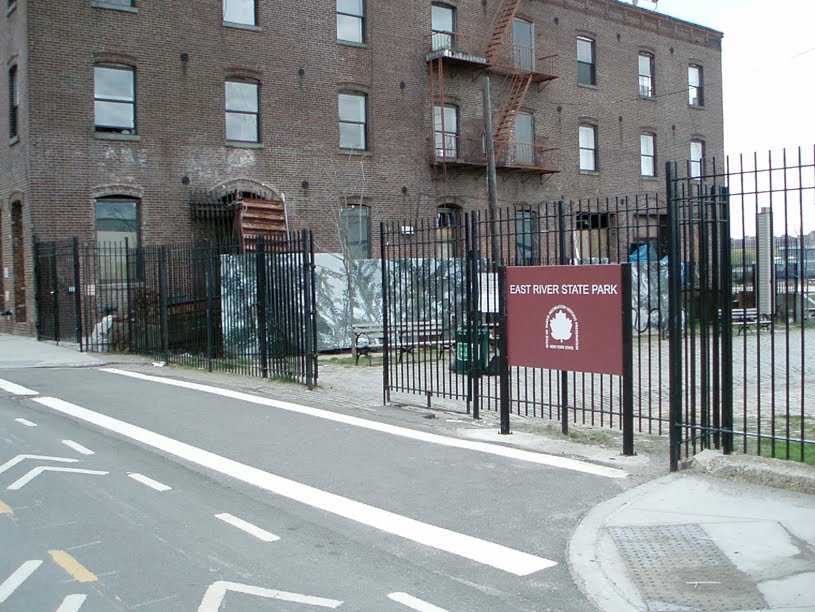 North 8th St. & Kent Ave.
 East River State Park
 East River State Park
 East River State Park
 View from East River State Park
 East River State Park
 East River State Park
 Bushwick Inlet Park
 Bushwick Inlet Park