After that I’ll try to go back and see more of the different neighborhoods I could only pass through previously for lack of time. In fact, I think the autumn might be the best time to go back to Prospect Park South, Midwood, and all the other generally branchy and leafy enclaves.
I’ve decided that one way to see Brooklyn, besides choosing an area and then wandering pretty much at random, is by taking some of the major avenues from start to finish. Either all in one go or in pieces. It has the advantage of taking me across whole swaths of Brooklyn, though a disadvantage is that if I stay only on the one road and haven’t the time to wander I can very well miss the meat of the neighborhoods I go through. But I figure I can always go back. It’s sort of a shorthand way of seeing a place. In fact, it gives me the perfect reason to keep going back.
On Sunday, it was the turn of New Utrecht Avenue since that could take me through at least two large neighborhoods and, by varying the route back a bit, get through two others: Borough Park, Bensonhurst, Bath Beach, and Dyker Heights.

This is one end of New Utrecht Avenue at 9th Avenue near Green-Wood Cemetery (the trees in the background). The building is the entrance to the D train; this is the point where it becomes elevated after having run underground through Sunset Park. (As usual, click on the photos for a larger view.)
There were two problems that kept me from enjoying this walk as much as I hoped I would: I had forgotten that Sunday was the first day of Sukkot and so most of Borough Park would be a wilderness with few people on the streets and almost all businesses closed; also, I didn’t realize until I got down to New Utrecht Avenue that for its entire length it was covered by the elevated D train tracks. Oh, well. Like I say, I can always go back.

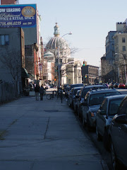
Near Fort Hamilton Parkway (above) where the elevated portion begins. This ia a couple of blocks from where I began, looking pretty much south down into Borough Park.

Near Fort Hamilton Parkway. Ft. Hamilton Parkway, by the way, runs from the Verrazano Bridge in a vauguely northeast direction almost to Prospect Park. It crashes into the top of Ocean Parkway a block or so from the park.
Most of the pictures here will just be random shots of the area; there isn’t any one thing more than another along New Utrecht Ave. to demand a photo, at least there wasn't the day I walked it. At one point, from sheer boredom, I did actually cut over a block to 13th Avenue but that didn’t help much since it was just as barren, so I went back to New Utrecht. Had I stayed on 13th Avenue I would have seen an improvement after awhile but my aim was to take New Utrecht Ave. all the way to the end so that’s what I did; I'm nothing if not bullheaded.

At 44th Street. The man is, I think, carrying a palm frond in a plastic covering. This is one of the "Four Kinds" that play an integral part in the observance of Sukkot. I think that in all the Jewish families I saw strolling through Borough Park that afternoon one person, usually a youngster, was carrying a palm frond. See the link at the end of this post for more information on Sukkot.

After there was a New Utrecht but before there was a Borough Park, there was Blythebourne. This was an area developed for housing amid the farms and nurseries of New Utrecht in the late 1880s. In the 20th century it was subsumed into the larger Borough Park that had been established not long after it had been. Blythebourne exists now only as a post office branch (above) at 55th Street. Still, any reminder of an area's past is valuable.
Now that I think of it, there was one thing I did make a point of photographing, the advertisements on the sides of a corner phone booth at 13th Avenue; and this only because of a certain cultural dissonance connected with them. You have to realize that Borough Park may well be the largest Hasidic community in New York; I don’t know how it compares to Williamsburg (the other major Brooklyn Hasidic community) in numbers, but it is almost entirely Hasidic in population, which is why the signs below took me by surprise.


Either side of a phone booth at 13th Avenue and New Utrecht Avenue.
I later found out from one of my invaluable books (The Neighborhoods of Brooklyn) that the very conservative nature of the Hasidic community in Borough Park has attracted a similarly conservative Muslim group that has moved there. Go figure. It’s New York. Maybe we can export the tolerance.

At 56th Street.

St. Francis de Chantal Church at 13th Ave. & 57th St. A Catholic presence as you get closer to Bensonhurst. St. Catherine of Alexandria Church was the first Roman Catholic church in the Borough Park area and is located on Ft. Hamilton Parkway a few blocks from New Utrecht Ave.
After 65th Street Borough Park gives way to Bensonhurst and though it isn’t an absolutely definitive line between the Hasidic Jewish neighborhood and the non-Jewish, soon I noticed more stores open for business and people more casually dressed. But the D train tracks stayed with me.

At 62nd Street. I couldn't resist. You never know when you will need a used police car!

At Ovington Avenue in Bensonhurst, I don't get it with the shoes on the power lines, never have. Maybe someone can enlighten me.
One thing that did intrigue me is that there is no longer a New Utrecht. It was one of the six original towns of Brooklyn (the others were Flatlands, Gravesend, Brooklyn, Flatbush, and Bushwick), it was the fifth one to be established (in 1657), and it is the only one to have disappeared as even the name of a neighborhood. It survives only as the name of the avenue, the local high school, and a couple of other things.

New Utrecht Reformed Church, 18th Avenue & 84th Street, a block from New Utrecht Avenue.
Bensonhurst was once a small section of a much larger New Utrecht and now all that remains of the original New Utrecht is a few blocks of Bensonhurst, mainly the area around the New Utrecht Reformed Church, which stands at 84th Street and 18th Avenue. The present church was built in 1829 using stones from the original church, itself built a few blocks away around 1700. There is probably more to this old New Utrecht in the area but since I came on it unexpectedly I didn’t have the time to spend wandering around there. But again, ample reason to return.


New Utrecht Avenue ends (or begins, depending on your point of view) at 86th Street, the main drag of Bensonhurst (above). The D train tracks curve east onto 86th and continue on to Coney Island. I went in the opposite direction.
I did have one other motive in heading to the Bensonhurst area: Vincent Gardenia. The late actor lived most of his life in Bath Beach, which abuts Bensonhurst; he was still living there at the time of his death in Philadelphia in 1992. He was always one of my favorite actors and I’m sad that I’ll never see him in another new movie. Last Memorial Day weekend, when I had lent my camera to a friend, I was in Bath Beach for the first time having walked out to Bay Ridge and then up into Bath Beach along the shore. That was when I first ran across Vincent Gardenia Boulevard. I found out later that after his death a portion of 16th Avenue through Bath Beach had been named in his honor. I was determined to return to get a picture of one of the street signs . . . and did.

"Vincent Gardenia Boulevard," 16th Avenue & Benson Avenue.

Dyker Beach Golf Course at 14th & Bath Avenues
From there I wasn’t sure where to go since I hadn’t any strict plan after New Utrecht and Mr. Gardenia. I simply wandered down Bath Avenue until it ended at Dyker Beach Park and golf course, which forms the western end of Bath Beach and the southern edge of Dyker Heights. From what I saw of the golf course and from what I know of golf courses it looked OK. And the park that adjoins it on the northern edge was OK too, and large enough to handle several soccer games and a little kids’ football match with room to spare for people picnicking or just relaxing.
As Monty Python used to say, now for something completely different, or a little different anyway, a couple of short videos of Dyker Beach Park. Just to break up the monotony of the prose and photos a bit. That's the arch of the Verrazano Bridge you see in the background of the second video (and a little in the first); that's how close it is to the bridge.
Along the 86th Street side were handball courts and even bocci courts (if that’s what they’re called); the lingua franca there seemed to be Italian. A pleasant place, a neighborhood place.

Bocci at Dyker Beach Park, 86th Street near 13th Ave.
At that point I realized that it was getting late, it was no longer July, I couldn’t count on day light until after 8.00 pm, and I’d better be heading back. Up a block on 86th St. and heading back north in my direction was 13th Avenue (the other end of the 13th Avenue I had been on for a bit in Borough Park). Over here it was also called Dyker Heights Boulevard. Since I guessed from the name that it was probably the main street of Dyker Heights I figured it was good way to go back. It reminded me a little of where I grew up in Connecticut when I was a kid, like some of the business streets: small, neat, well-kept brick buildings lining the avenue featuring many small shops and restaurants; people out strolling, doing a little shopping. Stretching off on either side were narrow streets of small houses. It had a nice friendly feel to it. It's also very Italian.

77th Street & 13th Avenue (Dyker Heights Blvd.).
And so, by way of 13th Avenue, back across Brooklyn to hearth and home in Williamsburg.

51st Street & 13th Ave., Borough Park.

45th Street & 13th Ave., Borough Park.
Below, sukkahs on Bedford Avenue in Williamsburg. People who don't have a yard to construct a sukkah in often will use the balcony of their apartment. Most of the large apartment houses in the Hasidic neighborhoods of Williamsburg have been built with high-railed balconies for just this purpose.


Read more about Sukkot