I spoke too hastily about the migration of the blog. It turns out that uploading a video to a blog post with the new host costs. It will be something like $59 per year per blog. I'm not sure I'll be using enough videos in the Brooklyn blog to warrant that. But I can't afford it right now anyway. So, I'll be hanging on to this blog as well for any videos I happen to want to add.
This one is of the unexpected storm we had today, 26 February.
Friday, February 26, 2010
Wednesday, February 24, 2010
Moving
This blog will be migrating to a new host. I am in the midst of trying to set up the new pages now but it's likely to take some time before I am familiar with all the widgets and extras and other things there. Still, that much being said, there will be no more new posts here though I'll keep a link to the remains on the new blog.
I know our winters are quirky here but it is almost March after all, so I'm confident it won' t be too long before I am out and about more and posting more.
The new blog is here:
Walking Brooklyn
This is an afterthought, written several days after the above. I found out that I can't yet post videos to the new blog. It will coat me some extra cash for that privilege, cash I can't afford at the moment. So I am keeping this blog for the time being.
I rarely post videos but, as it happens, I took some shots of the snow this afternoon (2/26) that I felt like posting so that goes here. The still photos, such as they are, will post to the new blog.
Friday, February 19, 2010
The Good, the Bad, and . . . Duane-Reade
The Midtowning of Williamsburg continues
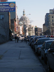
With the temperatures moderating a bit more lately, I had decided I could at least wander around my own neighborhood to see how new construction was progressing. I rarely do that, having a few fixed routes to the subway, the supermarket, and into South Williamsburg when I head off to the library.
So, when I do go down an unfamiliar street I am sometimes taken aback by the appearance a new building wedged into the block, usually something or somewhere totally inappropriate. I thought I might wander out later this weekend and take a survey.

Meanwhile, I had been keeping my eye on the large structure going up on Bedford Avenue near Metropolitan. Until recently it had been covered in scaffolding or netting or just hadn't progressed to the point of being clad so you really couldn't tell what it would look like. I was very much afraid it was going to be another one of those boring green glass things that have been sprouting up around North Brooklyn.

I have to say that when I saw it last week (above) I was pleasantly surprised. It's clad in a sort of cream colored stone or gray depending on the light and doesn't look bad at all.

It's still pretty large, though even the size doesn't seem as overwhelming as it did when it was all scaffolding and girders and cranes and machinery.


When I shot the photos last week I cannot figure out how I missed the large banners on the side and front of the building until this morning. I think I was in a hurry to get someplace else and being nearby with my camra just snapped a few shots and went on. But there was no denying it as I walked past on my way to the L train with my buttered bagel in hand.

I don't want to sound snotty or snobby but I really Do Not Like Duane-Reade. I was so happy to hear that they'd been bought out by Walgreens. Not that Walgreens is any less ubiquitous in New York, but I was hoping I'd never have to see that nauseating red and blue DR logo any more (even though Walgreens will probably keep the stores just as they are). And I've really never forgiven them for buying out and closing down the Rock Bottom drug store in Jackson Heights when I lived there about twenty years ago. A great crowded emporium carrying some of the most out-of-the-way products you'd ever see and one day it had turned into a bland and boring and ordinary (and short lived, as it turned out) Duane-Reade with maybe a quarter of the products.
Just what we need in this neck of the woods; we already have our Chelsea-sized glass and steel mega-apartment buildings screening off the river views, why not more of 6th Avenue? Maybe at the other end of the block, still unreconstructed, we'll get an H & M or a Gap. We couldn't get anything useful like a competitively priced supermarket or a few bank branches.
My city, my borough, but NOT my drugstore. My drugstore is Kings, directly across the street, small and friendly and now decidedly in danger.
Monday, February 1, 2010
New York City Map Time Capsule
That New York City map that I enjoy using so much, and that I have provided a link to here on the site, has added a really interesting new feature.
Now, not only are you able to switch to a close-up aerial view of any part of Brooklyn from today (actually, 2008), but you can also call up a view of the same area from 1924!!
Granted, the 1924 view is not as good as the contemporary one. The photos are black & white and the detail isn't as good, but you can definitely see the differences across the years.
You can see what the borough looked like before the Brooklyn-Queens Expressway was built, before the Verrazano Bridge was built, before some major buildings were thrown up, before the Robert Moses-inspired urban renewal replaced dense neighborhoods with towering projects.
I've placed a few 1924 vs. 2008 photos here just to give you an idea of what the 1924 map looks like. And here you definitely have to click on the photo to enlarge it in order to see any detail.
First a view above McCarren Park in Greenpoint, along Bedford and Driggs Avenues and Lorimer Street, The park is there in 1924 but the pool (the largest municipal pool in the city, I think, when it opened) is about a dozen years in the future; it will occupy the white trapezoidal shaped area north of the park in the 1924 view; just to the right of the Lorimer St. label in 2008. Automotive High School, just west of the park on Bedford Avenue wasn't built until 1937 (it's the "L"-shaped building just above the "Mc" in 2008). And you see that Greenpoint itself was much more industrial in those days, note all the above ground storage tanks dotting the area and more working piers (both of these more evident in the area of Greenpoint off the photo further north).


The view over Fort Greene Park isn't a great deal different except that what had been a dense neighborhood in 1924 along the Myrtle Avenue side of the park is today the site of more New York City housing projects (the "slum" to the right of the 12D label in 1924). And . . . no BQE above Park Ave. at the top of the map.

 A short sidelight on that area. I happened to be over there one Saturday last autumn taking pictures of one of the surviving Carnegie libraries on St. Edward's Street and also decided to take some shots of a very imposing Catholic church directly across the street from it. On the old map the church would be directly under the 12D label (the library is shown just to the right of the "D"). I got into conversation with an elderly man who was passing by and he asked if I knew what was curious about the church. When I said no, he told me that Al Capone had been baptized there. I had never given any thought to where Al Capone was born, probably thinking it was in Chicago. It turns out he was born only a few blocks away at 95 Navy Street (the family moved to Park Slope when he was 11). This invaluable map lists the church as dating from 1920 so either the date is wrong or the church was rebuilt. Since I've known other incorrect dates on the map, that doesn't surprise me.
Bay Ridge and Fort Hamilton, 2008.
 Bay Ridge and Fort Hamilton, 1924. Hey, dude, where's my bridge!?!

East Williamsburg, the site of the Williamsburg Houses that in 1939 were the largest slum-clearance and low-income housing project of the Federal Housing Project (Stagg Walk and Ten Eyck Walk), according to the 1939 WPA Guide to New York City. Whenever New York City wanted to raze a neighborhood and throw up some projects they brought out the word "slum"; that's all it took and you were out of there, too often left on your own to find other accommodation. They were designated a city landmark in 2003.
 A government report of the 1930s reportedly described the slums of the Williamsburg area of Brooklyn as bearing "the stamp of dull listlessness and despair." I can't imagine such government poetry today.

And there really were honest-to-goodness Navy ships in the Brooklyn Navy Yard in 1924.


That 1924 map looks like something you'd see in a Warner Bros. World War II thriller like All Through the Night, where Humphrey Bogart is trying to thwart the Fifth Columnists, or "Fivers," as he calls them, trying to blow up a ship in the Brooklyn Navy Yard, or where Norman Lloyd tried to blow up the ship near the end of Hitchcock's Saboteur (Universal not Warner's, before someone jumps down my throat about it).
Now, not only are you able to switch to a close-up aerial view of any part of Brooklyn from today (actually, 2008), but you can also call up a view of the same area from 1924!!
Granted, the 1924 view is not as good as the contemporary one. The photos are black & white and the detail isn't as good, but you can definitely see the differences across the years.
You can see what the borough looked like before the Brooklyn-Queens Expressway was built, before the Verrazano Bridge was built, before some major buildings were thrown up, before the Robert Moses-inspired urban renewal replaced dense neighborhoods with towering projects.
I've placed a few 1924 vs. 2008 photos here just to give you an idea of what the 1924 map looks like. And here you definitely have to click on the photo to enlarge it in order to see any detail.
First a view above McCarren Park in Greenpoint, along Bedford and Driggs Avenues and Lorimer Street, The park is there in 1924 but the pool (the largest municipal pool in the city, I think, when it opened) is about a dozen years in the future; it will occupy the white trapezoidal shaped area north of the park in the 1924 view; just to the right of the Lorimer St. label in 2008. Automotive High School, just west of the park on Bedford Avenue wasn't built until 1937 (it's the "L"-shaped building just above the "Mc" in 2008). And you see that Greenpoint itself was much more industrial in those days, note all the above ground storage tanks dotting the area and more working piers (both of these more evident in the area of Greenpoint off the photo further north).


The view over Fort Greene Park isn't a great deal different except that what had been a dense neighborhood in 1924 along the Myrtle Avenue side of the park is today the site of more New York City housing projects (the "slum" to the right of the 12D label in 1924). And . . . no BQE above Park Ave. at the top of the map.

 A short sidelight on that area. I happened to be over there one Saturday last autumn taking pictures of one of the surviving Carnegie libraries on St. Edward's Street and also decided to take some shots of a very imposing Catholic church directly across the street from it. On the old map the church would be directly under the 12D label (the library is shown just to the right of the "D"). I got into conversation with an elderly man who was passing by and he asked if I knew what was curious about the church. When I said no, he told me that Al Capone had been baptized there. I had never given any thought to where Al Capone was born, probably thinking it was in Chicago. It turns out he was born only a few blocks away at 95 Navy Street (the family moved to Park Slope when he was 11). This invaluable map lists the church as dating from 1920 so either the date is wrong or the church was rebuilt. Since I've known other incorrect dates on the map, that doesn't surprise me.
Bay Ridge and Fort Hamilton, 2008.
 Bay Ridge and Fort Hamilton, 1924. Hey, dude, where's my bridge!?!
East Williamsburg, the site of the Williamsburg Houses that in 1939 were the largest slum-clearance and low-income housing project of the Federal Housing Project (Stagg Walk and Ten Eyck Walk), according to the 1939 WPA Guide to New York City. Whenever New York City wanted to raze a neighborhood and throw up some projects they brought out the word "slum"; that's all it took and you were out of there, too often left on your own to find other accommodation. They were designated a city landmark in 2003.
 A government report of the 1930s reportedly described the slums of the Williamsburg area of Brooklyn as bearing "the stamp of dull listlessness and despair." I can't imagine such government poetry today.
And there really were honest-to-goodness Navy ships in the Brooklyn Navy Yard in 1924.


That 1924 map looks like something you'd see in a Warner Bros. World War II thriller like All Through the Night, where Humphrey Bogart is trying to thwart the Fifth Columnists, or "Fivers," as he calls them, trying to blow up a ship in the Brooklyn Navy Yard, or where Norman Lloyd tried to blow up the ship near the end of Hitchcock's Saboteur (Universal not Warner's, before someone jumps down my throat about it).
Subscribe to:
Posts (Atom)